Legal Department
- OSE Home
- About OSE
- About Legal
- Hydrographic Survey
Hydrographic Survey
The first stage of the adjudication process is the completion of the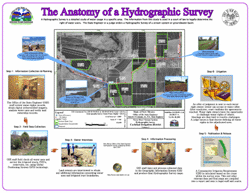 hydrographic survey. During this process, Hydrographic Survey Bureau and the Litigation and Adjudication Program staff gather all of the information used to legally describe a water right and record it in the report and associated maps filed withthe court. The survey filed by the bureau is presumed by the court to be correct. Any party wishing to dispute these facts bears the burden of proving the survey wrong.
The bureau makes every effort to ensure its information is correct. Staff search county ownership records, State Engineer water rights records, historical records, field surveys, field interviews, historical aerial photography and current aerial photography.
All new hydrographic surveys are based on geographic information systems (GIS) technology and all field measurements are now done with global positioning systems (GPS) receivers.
For more information about the Hydrographic Survey Bureau, contact 505 827-3879 or 7873.
Hydrographic Survey Maps & Reports
Animas Underground Water Basin Hydrographic Survey
Cow Creek Watershed Hydrographic Survey (2015)
Gila River Hydrographic Survey (1962-1966)
Lower Rio Grande Hydrographic Survey (1999-2000)
Mimbres Hydrographic Survey (1969 Surface & 1975 - 1982 Groundwater)
Nutt-Hockett Basin Hydrographic Survey (1997-1998)
Pecos River Basin Hydrographic Survey (1991)
Red River Hydrographic Survey (1973 - 1974 - 1999)
Rio Chama Basin Hydrographic Survey (1961 and 1974)
Rio del Oso & Rito Vallecitos Hydrographic Survey (2016)
San Cristobal Hydrographic Survey (1974)
San Juan River Basin Hydrographic Survey (1938 and 1980-1987)y.
Santa Fe River Hydrographic Survey (1976)