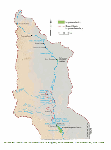
Pecos River Basin
From its source at an elevation of just over 12,000 feet in the southern Sangre de Cristo Mountains in north-central New Mexico, the Pecos River flows south and southeasterly for 970 miles to its confluence with the Rio Grande River in Amistad Reservoir on the Texas-Mexico border. The river’s drainage basin encompasses roughly 44,000 square miles, of which approximately 25,000 square miles (and the upper ~530 miles of the river itself) lie within New Mexico, accounting for roughly 20% of the state’s land area.
Within New Mexico, the Pecos River Basin extends from the 13,108’ Truchas Peak, (New Mexico’s second highest mountain) to the state’s lowest point at approximately 2,840’ where the river crosses into Texas. While most of the basin is relatively flat, semi-arid scrub and grassland, two major mountain ranges, the Sangre de Cristo Mountains and the Sacramento Mountains (as well as several smaller ranges) lie along the basin’s boundaries, and higher precipitation in these areas supplies most of the basin’s useable surface water and groundwater. The Pecos River Basin currently supports a population of roughly 180,000, or approximately 8% of New Mexico’s population.
As indicated above, the Pecos River provides water to both New Mexico and Texas. In New Mexico, the river and its tributaries have provided surface water to acequia communities in its upper reaches for centuries. Major development of Pecos River surface water for larger scale irrigation began in the Carlsbad area in the 1880s by significant groundwater development in the Roswell area. Today, irrigated agriculture remains the predominant beneficial use of Pecos River water. Competing demands for limited Pecos River supplies between New Mexico water users present an ongoing water-management challenge in the basin.
New Mexico is also required to deliver a portion of the Pecos River’s water to the state of Texas, but it took decades to develop accounting protocols that could be agreed upon by both states. After failed attempts to reach an agreement starting in the 1920s, New Mexico and Texas agreed in 1948 to the Pecos River Compact, which was signed into Federal law by President Truman in 1949.
Although the Compact was intended to remove causes of “present and future controversies,” it did not, and in 1974 Texas filed a complaint against New Mexico in the U.S. Supreme Court alleging chronic under-delivery of water in violation of the Compact. Ultimately, the Court ruled in favor of Texas, determining that New Mexico had underdelivered by over 340,000 acre-feet during the period 1950 through 1983, and decreeing that New Mexico must never again underdeliver water to Texas. New Mexico subsequently paid Texas $14 million in compensation to cover the underdelivery for the years 1952-1986. The lawsuit also resulted in the 1988 Amended Decree, which led to the appointment of a federal River Master to perform all Compact accounting in accordance with updated water accounting methodology contained in the River Master Manual. Should New Mexico’s ever fail to comply with the terms of the Compact and Decree, such failure could ultimately result in Federal intervention, whereby the state could lose its authority over water management in the basin.
To ensure protection of New Mexico water-right owners and compliance with the Pecos River Compact, state and federal stakeholders in New Mexico entered into the 2003 Pecos Settlement Agreement that implemented water-management strategies to better protect New Mexico’s interests in the lower Pecos River.
Under the terms of the Pecos Settlement Agreement, the NMISC Pecos Bureau operates and maintains two augmentation wellfields and pipelines, at Lake Arthur and Seven Rivers, to provide additional water to the Pecos River under specified conditions. The NMISC Pecos Bureau has established groundwater monitoring networks around its two wellfields. Groundwater elevation and water quality data from NMISC’s monitoring network are presented on the Technical Data and Resources page; this page also includes links to various technical articles and reports.
The NMISC Pecos Basin Bureau is also actively involved with Environmental Management Issues on the river; specifically, partnering with other water management entities to ensure compliance with the Biological Opinion for the Pecos bluntnose shiner (Notropis simus pecosensis), a threatened species under the federal Endangered Species Act. Other species of concern include the federally endangered Texas hornshell mussel (Popenaias popeii) and the Pecos pupfish (Cyprinodon pecosensis).
Additional information for the Pecos Bureau is provided on the sidebar to the right.